So far, it was almost noon and we had just entered the Subway. In the almost 4 hours we had been going, we had gotten lost hiking slickrock, and descended a precarious "trail" by using the time honored method of sliding upon our asses. On a more interesting note, both of our pairs of shorts we were wearing at the time seem to be irrevocably stained by the red earth that made up the "trail". Badge of glory, I guess.
Anyways, after a short rest to allow Becky a bit of time to compose herself for the rest of the hike, we set off down the canyon. At least the hardest part was behind us, right?

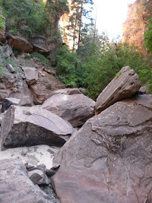
The path ahead...

I make my way across one of the many boulder fields at the canyon bottom

One of the many beautiful, yet fetid, pools at canyon bottom
Frankly, the next part of the hike was easy, and rather scenic. There was the occasional boulder to scramble across, the occasional pool that looked like it woul d be best to avoid, a tree here, some brush there. The canyon architecture was really something to behold. I'd be lying if I said that I wasn't in one of the most beautiful places I've ever been; the Subway, for as dangerous as it is, is simply put, absolutely stunning. Alas, the peaceful portions cannot continue, and we quickly approached our first obstacle--the boulder rappel.
This shows the approach--you climb over the boulders, veering right. Eventually, you find some webbing slung though a pinch point where a boulder rests against the canyon wall:
This shows the approach--you climb over the boulders, veering right. Eventually, you find some webbing slung though a pinch point where a boulder rests against the canyon wall:
To be perfectly honest, this wasn't as easy as I expected it to be. A lot of the trail guides talked about this being an awkward rappel, and saying nothing more, except the boulder could be downclimbed if you were experienced, and the easiest way to do the obstacle was to downclimb a narrow hole right next to the rappel point. After waitin g for the family hikers to finish the rappel, we checked our options:

The hole
As you can see, the rappel looked to be the far better option.
So, when it was our turn, we began the safety check of our ropes, evaluated the anchor webbing, found it all to our liking, and prepped the rappel.
While we were doing this, another experienced group came up behind us and proceeded to downclimb the boulder in about 5 minutes, before continuing jauntily on their way. Daaamn.
Anyways, we don't have pictures(sorry), but Becky and I quickly found out why the rappel was awkward: It started out as a normal rappel, but then at the lip of the boulder, the rock turned sharply inwards, and you lost any foot hold you might have. The solution was to turn slowly to the left, and then finish the rappel going down the canyon wall. This was made more difficult by the fact that the rappel was through a narrow space formed by another boulder. So, what did I do? Well, I did what I always did in these situations. I screwed it up.
I tried turning, only to have my feet slip out from under me. I fell back into space, and found my self dangling about 8 feet off the ground, my knees and knuckles scraping against the rock. Not my most graceful moment. However, our ropes held, and I quickly let myself down the rest of the way, more annoyed with myself than anything.
On the bright side, Becky did the exact same thing. Lucky for her, I was expecting it, and had my hands up ready to grab her and cushion the blow. She got through with only a small scrape. However, we were both on the ground, only slightly more wo rse for the wear and were ready to proceed. Yay! 1st obstacle complete! We go up a canyoneering level! Oh by the way, now that we had gone through a rappel, we were trapped. The only way out was forward. There was no climbing back up. Here's a picture I found that is of the first rappel looking back up. This is not our picture; just something I found on the web:

Now, here's a picture for you:

Any guesses as to how the trees ended up like that?
If you know, you'll know the danger that any canyoneer dreads more than any others (well, except maybe keeper potholes). The answer: flash floods.
Flash flooding is an extreme danger in slot canyons. The water, draining from up canyon when it rains, even just a little bit, has no place to go. That water builds up very quickly, and violently, and sweeps away anything in its path. Here's a nice example of that:
So yeah....danger danger and all that. If you get caught in a flash flood, chances of survival are not great. I mean, chances of survival are approaching "zero". They're that bad. There are canyons in Zion that if it even threatens to rain in the the few days before and during the hike, you call it off. The Subway has less of a chance than most...but you still don't want to get caught. Chance of rain when we left was 30% chance of storms that night, clear for the day. When we started the hike, there was not a single cloud in the sky. Anyways, my point is, seeing things like that in the canyon walls serves as a very real reminder that you do not want to be there if it rains, and to always be keeping your eyes out for high ground.
For those who do not like suspense: No, we did not get caught in a flash flood. It did not flash flood when we were there. Just trying to create a bit of mood and a bit of background of what was going through our heads as we saw this, and also noticed that there were now a few clouds.
Another half an hour down the road, and we came to our first pool that we couldn't avoid. It was only about a foot deep, but man was it stinky. Hundreds of water bugs skimming across the surface, algae, the works. I've liked the word "fetid" and I shall continue to use it. Anyways, we knew that the water was only going to get deeper at this point, so we took off our socks, stuffed them in the dry bag we brought along, as well as anything else we didn't want to get wet. It made for a pretty heavy dry bag. Becky offered to carry the bag though, as I had the rope--the rope didn't exactly repel water and weighed about twice as much when wet, so I guess it was generally fair. I think I got the better part of the deal though.
With that, and with a bit of ewwwww.....we stepped into the water. And all thoughts of its fetidness vanished. Because let me tell you....it was cold. I'm not talking cold shower cold, or man, I wish that pool had a heater cold. I'm talking freezing, ice cold. I'm talking 40 degree cold. Possibly 50 degree, but let me tell you, at that point, there's not a lot of difference between 40 and 50 degree water. Both will cause hypothermia with equal ease. This was "take-your-breath-away" cold, and we had just stuck our feet into it. If the only way out wasn't forward, I would have had serious misgivings about that which was to come. But we were past the point of no return, and the only way out was forward.
We quickly waded the small pool, grateful to get out. A few hundred feet down, we were greeted by another pool, which we elected to climb over using a rock shelf, rather than wade. A bit beyond that, we were wading up to our knees, and the water seemed to only grow colder. And then....we were at the next major obstacle--the 40 yard swim.
When we got here, I wasn't expecting it to be a particularly bad obstacle. By most accounts, this was going to be the big swim of the day, and if we got past this, we'd have some wading, but not much more. A picture of what it was supposed to look like is located here.
Strange thing about that picture. That rock at the end that seems to be the place to climb up. Strangely missing. In fact, what we encountered was not what it looked like at all. For one, it was longer. Second, see the high water mark in the picture, marked by the dark rock? The water was all the way up there. In fact, there was no climb down into the water at all. There was the entrance, and then, just water. I didn't realize it at the time, but the water, all through out the canyon, was significantly higher than I had thought going in. This would become a problem later on.
For now, I bit my lip, dangled on the end, and then plunged in, backpack, shoes and all. And let me tell you, it was like having a knife stabbed into my ribs. That water cut through me like a razor blade, and I could barely breathe. I don't know how many of you have ever swum in icy cold water, but it was not an experience I cared to repeat. The water was dark--you couldn't see the bottom. What looked like a relatively close edge suddenly got a lot farther away, with the realization that you were freezing cold. And all you can think about is getting out. I tried to swim...but here's another thing about cold water. It's exhausting. Your body suddenly goes into overdrive mode, using all its available energy to simply keep yourself warm, to avoid hypothermia. Your muscles seize up, suddenly deprived of the energy it needs. I found myself suddenly unable to do a simple freestyle stroke, and I was suddenly dog paddling the best I could to get to that other side as quickly as possible. That rock in the picture? Submerged by about 3 to 4 feet of water. The pool was suddenly that much longer. When I got to the lip, which was submerged, I had a moment of panic when I tried to grab on and found that it was too slippery to hold onto. I solved the problem by giving a mighty kick and pushing myself onto the ledge, finishing up by laying there on my stomach.
As I got out, all I could think was: "Damn. That's one of the most dangerous things I've ever done". The water is so cold, it feels like it's pulling you down. In retrospect, that might have been the rope suddenly gaining about 15 pounds, but still. Terrifying.
I think Becky may have been watching all of this, and utilizing that mind reading ability she occasionally has, because as she sat on the lip, awaiting her turn, she suddenly got that look on her face that said "I do not want to do this".
I can't say that I blamed her. The pool was, to paraphrase Robert Frost, lovely, dark and deep. It was long. And I know that she knew a lot more about icy cold waters, being raised upon Lake Erie, than I did. Unfortunately, she did exactly what she shouldn't do in these situations: Panic. I won't go into the specifics, but let me say that it took about 5 minutes for me to convince her to make the swim. During the time, I pleaded, I cajoled, I encouraged, I got stern, I tried everything I knew. Eventually she slipped in, and swam frantically for the other side. Knowing the problems I had had getting out, I was waiting there to grab her hand and pull her up. Afterwards, shivering violently, we both sat in the sun for the next few minutes, laying our shirts upon a warm rock to try to dry them off. Luckily, we were past the worst of it. Or so I thought.
Problem was, the pools continued. Some were waist deep wades. Some were chin deep wades. Some were slightly deeper than chin deep swims. Nothing as difficult as what we just went through, but just as cold. Each one sapped our spirits just a little more. The walls of the canyon started becoming extremely narrow, and we carefully made our way down a short down climb over some sharp rocks. If the conditions were dryer, we probably could climb up those rocks. However, the higher water levels made a tiny waterfall run over them...they were very treacherous and an attempt to climb up would have been foolhardy at best. 50 feet beyond that, and we were at the bowling balls. There's a common picture of the location here.
It's a nice picture. We didn't take our own, because we just wanted to get the hell out of the canyon at this point. The swims were making us miserable, and we were freezing. Getting out a camera at this point would have required digging through the dry bag, which would have wasted time, and like I said, we were freezing. The walls were high and narrow enough, and had been for the last 20 or so minutes, that sunlight wasn't really penetrating the canyon. We were both shivering pretty hard, and our clothes were soaked.
But here's the thing about that picture. See how the guy in it is wading in water that is around his thighs, maybe up to his waist? Videos I had seen of people wandering the subway also showed this part, with people happily frolicking in waist to chest deep water. Good times. Easy to get through.
But the water here wasn't like that. Not at all. Yes, we had had clues that this would be the case. The 40 yard swim was both longer and deeper than the pictures. Pools and wades where there had been none in any trip report I saw. We learned later that rains over the past several days had made the canyon's water far deeper than it normally is. What I knew is that there was a rappel required here, because of a new mini waterfall that hadn't been listed, and that when we tossed the rope down into the water, the bright orange colored rope was only barely visible through the crystal clear water surface. This wasn't fetid water; it was fresh and flowing. It was just deep. Oh, and did I mention cold?
At this point, I think it was my turn to panic. I knew several facts, and they were adding up to something that was not good.
Fact 1: I am not a strong swimmer. I have never been a strong swimmer. When picking this, I figured, yes, I could swim 40 yards, longer than that, no problem. But, as a rule, I'm no good at swimming. One thing I can't do very well, if at all? Tread water.
Fact 2: Cold water made me a far worse swimmer than I already was.
Fact 3: The distance between the end of the rappel and the far edge was at least 50 yards. Then, it could have been a hundred for all it mattered.
Fact 4: The water did not get shallower.
Fact 5: The swims and wades before this point had exhausted both Becky and myself to the point of collapse. We were already freezing cold, shivering violently, and hypothermia was a concern if we couldn't find a place to warm up.
Fact 6: If the water was over our heads at the drop point, retrieving the rope was going to be difficult--we hadn't been trained on rappelling into deep water, and our instructor didn't think it was going to be an issue.
These added up to one conclusion--I was at that point, for the first time that day, in real fear for our lives. The way I looked at it, if I went first, I would, at best, be head deep in freezing cold water. I could, if I was lucky, hang around and help Becky with her rappel. But I also knew, realistically speaking, that if I was in that water too long, hypothermia would become an issue. Also, if I stayed there, I might not have the energy to swim out. If Becky went first, I would have to get the rope, and I wasn't sure I could do that, and also have the energy or be able to tread water long enough to do that. All I knew, at that point, was that if something went wrong, one, possibly both of us, could, at the very least, be trapped in the canyon until we were rescued, probably not until the next day. That's if the cold didn't get us first.
So, yeah. I panicked. It was Becky's turn to calm me down, what with the dry heaving and the shaking and all. She did all the things that I had done for her during the downclimb and the 4o yard swim, and if she hadn't been there, I don't think I could have done it.
She decided that since she was the stronger swimmer, she would go last. Her experience as a sailor gave her confidence that she could tread water, if it came to that, long enough to retrieve the rope. Once I was down, I was to stay if I could and help her out, but if I felt that I couldn't make it, to make for the opposite shore. Either way, I needed to keep moving, no matter what, once I was down. Numb with fear, I hooked in, and started the rappel.
I gotta tell you, that was one of the scariest moments of my life. Not the actual rappel. The fear of what was coming next. Slowly, my feet entered the water. And then my legs. And then my chest. I searched below for something, anything, with which to brace. Finally, chin deep, I found a small outcropping jutting from the wall I had just rappelled. While bracing with one hand, I was able to disconnect and stay perched there without going under. I was freezing. I was terrified. But I could at least stay and make sure we both made it through this.
Becky was already hooked up when I was most of the way down, and as soon as I was disconnected, she started down immediately. About 30 seconds later, she was down, and then we both, while perched on a small rock, frantically trying to get the rope down. Once it was down, we bundled it up the best we could held it...somewhere--I don't remember where--and frantically swam as best we could towards the opposite end. Half way through there was a small ledge that divided the canal, and we pulled ourselves up and over. Finally, we made it out and just collapsed on the other side. We had made it.
To be continued....
So, when it was our turn, we began the safety check of our ropes, evaluated the anchor webbing, found it all to our liking, and prepped the rappel.
While we were doing this, another experienced group came up behind us and proceeded to downclimb the boulder in about 5 minutes, before continuing jauntily on their way. Daaamn.
Anyways, we don't have pictures(sorry), but Becky and I quickly found out why the rappel was awkward: It started out as a normal rappel, but then at the lip of the boulder, the rock turned sharply inwards, and you lost any foot hold you might have. The solution was to turn slowly to the left, and then finish the rappel going down the canyon wall. This was made more difficult by the fact that the rappel was through a narrow space formed by another boulder. So, what did I do? Well, I did what I always did in these situations. I screwed it up.
I tried turning, only to have my feet slip out from under me. I fell back into space, and found my self dangling about 8 feet off the ground, my knees and knuckles scraping against the rock. Not my most graceful moment. However, our ropes held, and I quickly let myself down the rest of the way, more annoyed with myself than anything.
On the bright side, Becky did the exact same thing. Lucky for her, I was expecting it, and had my hands up ready to grab her and cushion the blow. She got through with only a small scrape. However, we were both on the ground, only slightly more wo rse for the wear and were ready to proceed. Yay! 1st obstacle complete! We go up a canyoneering level! Oh by the way, now that we had gone through a rappel, we were trapped. The only way out was forward. There was no climbing back up. Here's a picture I found that is of the first rappel looking back up. This is not our picture; just something I found on the web:
Photo from www.bluugnome.com
Now, here's a picture for you:
Any guesses as to how the trees ended up like that?
If you know, you'll know the danger that any canyoneer dreads more than any others (well, except maybe keeper potholes). The answer: flash floods.
Flash flooding is an extreme danger in slot canyons. The water, draining from up canyon when it rains, even just a little bit, has no place to go. That water builds up very quickly, and violently, and sweeps away anything in its path. Here's a nice example of that:
So yeah....danger danger and all that. If you get caught in a flash flood, chances of survival are not great. I mean, chances of survival are approaching "zero". They're that bad. There are canyons in Zion that if it even threatens to rain in the the few days before and during the hike, you call it off. The Subway has less of a chance than most...but you still don't want to get caught. Chance of rain when we left was 30% chance of storms that night, clear for the day. When we started the hike, there was not a single cloud in the sky. Anyways, my point is, seeing things like that in the canyon walls serves as a very real reminder that you do not want to be there if it rains, and to always be keeping your eyes out for high ground.
For those who do not like suspense: No, we did not get caught in a flash flood. It did not flash flood when we were there. Just trying to create a bit of mood and a bit of background of what was going through our heads as we saw this, and also noticed that there were now a few clouds.
Another half an hour down the road, and we came to our first pool that we couldn't avoid. It was only about a foot deep, but man was it stinky. Hundreds of water bugs skimming across the surface, algae, the works. I've liked the word "fetid" and I shall continue to use it. Anyways, we knew that the water was only going to get deeper at this point, so we took off our socks, stuffed them in the dry bag we brought along, as well as anything else we didn't want to get wet. It made for a pretty heavy dry bag. Becky offered to carry the bag though, as I had the rope--the rope didn't exactly repel water and weighed about twice as much when wet, so I guess it was generally fair. I think I got the better part of the deal though.
With that, and with a bit of ewwwww.....we stepped into the water. And all thoughts of its fetidness vanished. Because let me tell you....it was cold. I'm not talking cold shower cold, or man, I wish that pool had a heater cold. I'm talking freezing, ice cold. I'm talking 40 degree cold. Possibly 50 degree, but let me tell you, at that point, there's not a lot of difference between 40 and 50 degree water. Both will cause hypothermia with equal ease. This was "take-your-breath-away" cold, and we had just stuck our feet into it. If the only way out wasn't forward, I would have had serious misgivings about that which was to come. But we were past the point of no return, and the only way out was forward.
We quickly waded the small pool, grateful to get out. A few hundred feet down, we were greeted by another pool, which we elected to climb over using a rock shelf, rather than wade. A bit beyond that, we were wading up to our knees, and the water seemed to only grow colder. And then....we were at the next major obstacle--the 40 yard swim.
When we got here, I wasn't expecting it to be a particularly bad obstacle. By most accounts, this was going to be the big swim of the day, and if we got past this, we'd have some wading, but not much more. A picture of what it was supposed to look like is located here.
Strange thing about that picture. That rock at the end that seems to be the place to climb up. Strangely missing. In fact, what we encountered was not what it looked like at all. For one, it was longer. Second, see the high water mark in the picture, marked by the dark rock? The water was all the way up there. In fact, there was no climb down into the water at all. There was the entrance, and then, just water. I didn't realize it at the time, but the water, all through out the canyon, was significantly higher than I had thought going in. This would become a problem later on.
For now, I bit my lip, dangled on the end, and then plunged in, backpack, shoes and all. And let me tell you, it was like having a knife stabbed into my ribs. That water cut through me like a razor blade, and I could barely breathe. I don't know how many of you have ever swum in icy cold water, but it was not an experience I cared to repeat. The water was dark--you couldn't see the bottom. What looked like a relatively close edge suddenly got a lot farther away, with the realization that you were freezing cold. And all you can think about is getting out. I tried to swim...but here's another thing about cold water. It's exhausting. Your body suddenly goes into overdrive mode, using all its available energy to simply keep yourself warm, to avoid hypothermia. Your muscles seize up, suddenly deprived of the energy it needs. I found myself suddenly unable to do a simple freestyle stroke, and I was suddenly dog paddling the best I could to get to that other side as quickly as possible. That rock in the picture? Submerged by about 3 to 4 feet of water. The pool was suddenly that much longer. When I got to the lip, which was submerged, I had a moment of panic when I tried to grab on and found that it was too slippery to hold onto. I solved the problem by giving a mighty kick and pushing myself onto the ledge, finishing up by laying there on my stomach.
As I got out, all I could think was: "Damn. That's one of the most dangerous things I've ever done". The water is so cold, it feels like it's pulling you down. In retrospect, that might have been the rope suddenly gaining about 15 pounds, but still. Terrifying.
I think Becky may have been watching all of this, and utilizing that mind reading ability she occasionally has, because as she sat on the lip, awaiting her turn, she suddenly got that look on her face that said "I do not want to do this".
I can't say that I blamed her. The pool was, to paraphrase Robert Frost, lovely, dark and deep. It was long. And I know that she knew a lot more about icy cold waters, being raised upon Lake Erie, than I did. Unfortunately, she did exactly what she shouldn't do in these situations: Panic. I won't go into the specifics, but let me say that it took about 5 minutes for me to convince her to make the swim. During the time, I pleaded, I cajoled, I encouraged, I got stern, I tried everything I knew. Eventually she slipped in, and swam frantically for the other side. Knowing the problems I had had getting out, I was waiting there to grab her hand and pull her up. Afterwards, shivering violently, we both sat in the sun for the next few minutes, laying our shirts upon a warm rock to try to dry them off. Luckily, we were past the worst of it. Or so I thought.
Problem was, the pools continued. Some were waist deep wades. Some were chin deep wades. Some were slightly deeper than chin deep swims. Nothing as difficult as what we just went through, but just as cold. Each one sapped our spirits just a little more. The walls of the canyon started becoming extremely narrow, and we carefully made our way down a short down climb over some sharp rocks. If the conditions were dryer, we probably could climb up those rocks. However, the higher water levels made a tiny waterfall run over them...they were very treacherous and an attempt to climb up would have been foolhardy at best. 50 feet beyond that, and we were at the bowling balls. There's a common picture of the location here.
It's a nice picture. We didn't take our own, because we just wanted to get the hell out of the canyon at this point. The swims were making us miserable, and we were freezing. Getting out a camera at this point would have required digging through the dry bag, which would have wasted time, and like I said, we were freezing. The walls were high and narrow enough, and had been for the last 20 or so minutes, that sunlight wasn't really penetrating the canyon. We were both shivering pretty hard, and our clothes were soaked.
But here's the thing about that picture. See how the guy in it is wading in water that is around his thighs, maybe up to his waist? Videos I had seen of people wandering the subway also showed this part, with people happily frolicking in waist to chest deep water. Good times. Easy to get through.
But the water here wasn't like that. Not at all. Yes, we had had clues that this would be the case. The 40 yard swim was both longer and deeper than the pictures. Pools and wades where there had been none in any trip report I saw. We learned later that rains over the past several days had made the canyon's water far deeper than it normally is. What I knew is that there was a rappel required here, because of a new mini waterfall that hadn't been listed, and that when we tossed the rope down into the water, the bright orange colored rope was only barely visible through the crystal clear water surface. This wasn't fetid water; it was fresh and flowing. It was just deep. Oh, and did I mention cold?
At this point, I think it was my turn to panic. I knew several facts, and they were adding up to something that was not good.
Fact 1: I am not a strong swimmer. I have never been a strong swimmer. When picking this, I figured, yes, I could swim 40 yards, longer than that, no problem. But, as a rule, I'm no good at swimming. One thing I can't do very well, if at all? Tread water.
Fact 2: Cold water made me a far worse swimmer than I already was.
Fact 3: The distance between the end of the rappel and the far edge was at least 50 yards. Then, it could have been a hundred for all it mattered.
Fact 4: The water did not get shallower.
Fact 5: The swims and wades before this point had exhausted both Becky and myself to the point of collapse. We were already freezing cold, shivering violently, and hypothermia was a concern if we couldn't find a place to warm up.
Fact 6: If the water was over our heads at the drop point, retrieving the rope was going to be difficult--we hadn't been trained on rappelling into deep water, and our instructor didn't think it was going to be an issue.
These added up to one conclusion--I was at that point, for the first time that day, in real fear for our lives. The way I looked at it, if I went first, I would, at best, be head deep in freezing cold water. I could, if I was lucky, hang around and help Becky with her rappel. But I also knew, realistically speaking, that if I was in that water too long, hypothermia would become an issue. Also, if I stayed there, I might not have the energy to swim out. If Becky went first, I would have to get the rope, and I wasn't sure I could do that, and also have the energy or be able to tread water long enough to do that. All I knew, at that point, was that if something went wrong, one, possibly both of us, could, at the very least, be trapped in the canyon until we were rescued, probably not until the next day. That's if the cold didn't get us first.
So, yeah. I panicked. It was Becky's turn to calm me down, what with the dry heaving and the shaking and all. She did all the things that I had done for her during the downclimb and the 4o yard swim, and if she hadn't been there, I don't think I could have done it.
She decided that since she was the stronger swimmer, she would go last. Her experience as a sailor gave her confidence that she could tread water, if it came to that, long enough to retrieve the rope. Once I was down, I was to stay if I could and help her out, but if I felt that I couldn't make it, to make for the opposite shore. Either way, I needed to keep moving, no matter what, once I was down. Numb with fear, I hooked in, and started the rappel.
I gotta tell you, that was one of the scariest moments of my life. Not the actual rappel. The fear of what was coming next. Slowly, my feet entered the water. And then my legs. And then my chest. I searched below for something, anything, with which to brace. Finally, chin deep, I found a small outcropping jutting from the wall I had just rappelled. While bracing with one hand, I was able to disconnect and stay perched there without going under. I was freezing. I was terrified. But I could at least stay and make sure we both made it through this.
Becky was already hooked up when I was most of the way down, and as soon as I was disconnected, she started down immediately. About 30 seconds later, she was down, and then we both, while perched on a small rock, frantically trying to get the rope down. Once it was down, we bundled it up the best we could held it...somewhere--I don't remember where--and frantically swam as best we could towards the opposite end. Half way through there was a small ledge that divided the canal, and we pulled ourselves up and over. Finally, we made it out and just collapsed on the other side. We had made it.
To be continued....


