Hello! I'm going to be posting more than one day today because I seem (through no fault of my own and the entire fault lying with my handlers) to have fallen behind a bit.
Day 8-
So, when we last left off we had collapsed into bed at the Old Faithful Inn, having not managed to see everything we came to the Upper Geyser Basin to see. So, we decided to get up early the next morning and see what there was to be seen arounfdthe Inn. We were aided in this by the fact that some guest's car alarm was going off all night long, keeping us perpetually awake. Whoever that person is who let it keep carrying on like that should be shot. Here we are bright and early the next day in front of a thermal feature.
We had heard the hike up to Observation Point was a great way to see the whole geyser basin and, since it was allegedly short and with only 200 feet worth of elevation, we figured it would be a breeze. Well, it wasn't a breeze. We were still all tired and sore from the previous two days hikes. And the view...

Meh.
We left, unimpressed, to visit the remainder of the thermal features.
I've mentioned previously the mats of bacteria that live in the runoff streams of the thermal features and give them pretty colors. Here's a close up view of them to give you a good idea of what they really look like.


We had been wanting to see Old Faithful go off again, but he was a tad early. As such, we were all the way across the basin when he blew. Handler 1 was disappointed, but cheered up at the thought of breakfast at the lodge. Breakfast turned out to be far better than the basically invisible (it was very dark in the dining room) meal we'd had the night before.
The geyser board said Castle Geyser was set to go off around 11:20. Handler 1 had heard this was a good geyser to see, so she convinced Handler 2 to stick around and watch it (even though this would put them behind schedule for other things).
So, we headed out to Castle Geyser, found a good photo spot, and sat down to wait.
And wait.
11:20 came and went.

Still waiting...

Ah! There we are. Castle turned out to be a really neat geyser to watch, however, now it was time to end our little visit to Yellowstone (to the tune of Handler 1's sobs and pleading to stay another day). We took a picture of Moose Falls on our way out of the park.

After waiting some time at a construction point between the two parks, we entered Grand Teton National Park.

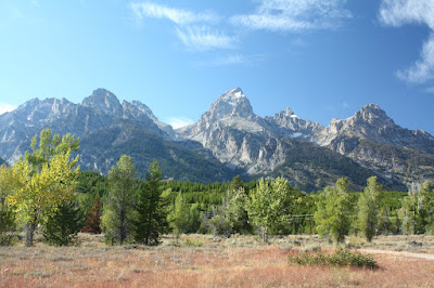
Grand Teton appears to be a succession of lovely mountain landscape views which, when not obscured by haze, are otherwise obscured by smoke from huge nearby forest fires.

Needless to say, this made the photos Handler 1 was so hoping to take at the famous picture spot known as the Oxbow Bend not come out good at all.

Luckily, there was still some wildlife to look at. We found a 'jam' complete with ranger escorts, and knew we'd find something neat when we got out of the car. It turned out to be a bull moose.


We continued taking photos of the pretty mountains.

This is the view from atop Signal Mountain which, much as Observation Point was not worth the climb earlier in the morning, really wasn't worth the slow winding drive up and back.

 We then went to find a somewhat mythical place known as 'Mormon Row', where stand a few old abandoned barns that people like to take pictures of. We ran into some old friends along the way.

And here's Mormon Row. At least, here's one barn of it. Handler 1 isn't sure whether she missed the other barns or if the old things finally collapsed under their own weight. Regardless, this ended up being one of the more useless of sidetrips.
 Our next stop was in Jackson, Wyoming. Apparently, there was some sort of art festival going on, with a pet adoption event and a marathon run planned for the next day. In other words, the place was packed.
Our aim in coming here was mainly to obtain dinner, which was had at a local bar/pizza parlor. We had the best beer here that we've had on the trip thus far. The Snake River Lager.

After dinner is when things began to fall apart. One of the grandhandlers...I won't name names, but you know who you are...suggested taking a path through Idaho to get to our next destination. He did not mention that said path would be through high, twisting, mountain roads that really should not be traversed at night.
Not to mention the loose stock. There are places out west where ranchers just let their cows roam free on public land, without payin any attention to what might happen to them or the motorists they jump in front of on the road.
Well, to make a long story short, Handler 2 white knuckled the drive for some time, almost killed a cow and very thoroughly blamed Handler 1 for all of it. Handler 1 took offense at this, and just tried to find them the fastest way back to the freeway possible. Handler 2's nerves were shot, so we decided to stay in the first town that offered a Super 8. There was no room at the in the first place we tried, but lodgings were eventually found in Orem, Utah.
Day 9-
The next day we headed south through the Beehive State, which you can tell by the fact that all of their state highway signs have a beehive on them. We passed quickly through Salt Lake City, and though we stopped off to see the Temple, the main road in front of it was closed for construction and we really didn't see the point of bothering to find parking for a building we wouldn't be allowed inside anyways.
Okay, so here's an interesting fact. In Salt Lake City, all the roads are named in reference to their location comparative to the Temple. So, the road running N/S 400 yards to the east of the Temple is 400 East. The road running E/W 400 yards south of the Temple is 400 South. And so forth. Other cities in Utah repeat this methodology, although they seem to use the individual town center as a point of reference.
Now, some of the more astute readers may have come to a startling conclusion upon reading this description. What happens when 400 South runs east far enough to intersect 400 East? Exactly what you'd expect. You get the corner of 400 South and 400 East, and yes, people in Utah are crazy.
After leaving the comparative civilization of Provo, we headed into the backcountry to take the historic Burr Trail through southern Utah. We passed within a stone's through of Capitol Reef National Monument, where red sandstone cliffs rise out of the desert.


We then entered Grand Staircase Escalante National Monument. Handler 2 began to get worried as we increased our elevation. Likely, he was remembering the trouble from the previous evening. Soon, beatiful canyons formed on either side of the road.

And when I say either side, what I really mean is both sides at once.

You can't see it particularly well, but there are 500+ foot cliffs beyond the trees and scrub edging this road. This, actually, was one of the wider parts where you could safely pull a car off on the shoulder. We later heard that this road is termed the Hogsback. Handler 1 thought it was great. Handler 2's palms sweated the whole way down into flat country.

It shoulod be noted that Handler 2 did have something to distract him from his abject terror as the Michigan-Notre Dame game was playing on the radio. It was also a nailbiter, but our mighty wolverines were victorious in the end!

Seriously, who stuck me with these juveniles?
And when I say either side, what I really mean is both sides at once.
You can't see it particularly well, but there are 500+ foot cliffs beyond the trees and scrub edging this road. This, actually, was one of the wider parts where you could safely pull a car off on the shoulder. We later heard that this road is termed the Hogsback. Handler 1 thought it was great. Handler 2's palms sweated the whole way down into flat country.
It shoulod be noted that Handler 2 did have something to distract him from his abject terror as the Michigan-Notre Dame game was playing on the radio. It was also a nailbiter, but our mighty wolverines were victorious in the end!
After exiting Grand Staircase, we took a quick 9 mile jaunt off our intended path to Kodachrome Basin State Park. Handler 1 had one, and only one, reason for wanting to go to this park. To take this photo.
Seriously, who stuck me with these juveniles?
We had reservations in Hurricane, Utah, but had to pass through part of Bryce Canyon National Park to get there. Handler 2 wanted to stop at the visitor center and check out information about star watching parties. There was apparently a star talk and viewing scheduled for later that evening, and Handler 2 wanted to do it. Handler 1 didn't want to, mainly because she knew it might lead to more mountain driving at night and didn't was a repeat of the previous evening. However, she eventually consented.
The talk was interesting, and the star viewing would have been interesting but for all the clouds. A small rainstorm was moving in and so, even with 3 high powered telescopes, it was hard for the rangers to keep anything in view for any length of time. We did, however, get to see some double stars in the constellation of the Big Dipper.
After that, Handler 2 did, in fact, drive through the mountains (and through a fairly treacherous swtichback portion of Zion National Park) in the dark. However, nary a word of complaint was spoken. We found our hotel and crashed. We would have to get up very early the next day to be on time for our Bryce Canyon horseback ride.
Note:
ReplyDeleteThis Grandhandler would like to set the record straight with regards to the route out of Jackson, Wyo. to Idaho. Yes, there is a winding stretch right out of Jackson heading west. It follows the Snake River and is actually quite scenic, livestock notwithstanding. G-handler believes it could be considered a cautious drive if one has never taken it before, especially at night where (as anyone who has ever driven in mountains will attest) there are no lights, save for your vehicle's headlights.
But scary? About as scary as baby's yawn. And once you cross the river about a half hour later, that's it. You're into Idaho which does have windy roads in spots, but little to no elevation. The road crosses potato-growing valleys all the way to Soda Springs, and later, the freeway south.
So, in the future, when encountering twisty, unfamiliar roads, this G-handler would like to offer one word of advice: Xanax.
Works wonders for vertigo, anxiety, and other travel maladies. It even works on stray cows, although you have to get them to swallow it.